


Her skirt would stand up straight and have to be thawed out.
Previously: I found it a matter of no small difficulty to collect the bills due by females who have been assisted to the Colony.

In this post we explore the Sligo family’s second sojourn in Victoria in the old mining district of Mt. Bealiba, family births and deaths, a return to Otago, Dunedin becoming New Zealand’s largest city, mining in Macetown, new approaches and technology in Otago gold mining initially via leads, the shafts dug to reveal ancient deposits of gold buried in primeval river courses, a developing awareness of the crucial nature of geological knowledge, the need for advanced engineering practices for quartz reef mining and dredging, hydroelectricity, and the challenges of life in Macetown’s extreme climate.
In these posts, I tell of two of my ancestors who arrived in Aotearoa New Zealand in 1861. My Irish great-great-grandmother, Maria Dillon, landed in January, just a few months before the gold rush that would utterly transform Dunedin and the province of Otago. My great-grandfather, the Scotsman Archie Sligo, was among the flood of hopeful diggers who disembarked in October of that year. I wanted to learn more about the forces that propelled them from their homelands, what attracted them to their new country, what happened here shortly before they arrived, and what they encountered as they set about making new lives for themselves. These posts reveal part of their stories.
Jessie and their children had joined Archie in Otago in 1862, and indications are that the family continued to do well. However, the two of them had been thinking about their previous life in Victoria. As the easily won alluvial gold in Central Otago continued to diminish, they decided to test their luck again back in Australia. By 1868, the family had left New Zealand and were living at Sebastopol in Victoria. The township had been named after a major siege in the Crimean War in 1854-55.
On 22 August, the fifth son Archibald was born there, his father on the birth certificate again recorded as a miner. Sebastopol had nine significant alluvial gold leads, with up to about 20 separate mines on each. In addition, there were three main quartz lodes (Consols, Guiding Star and Albion) containing about 15 individual mines.[1]
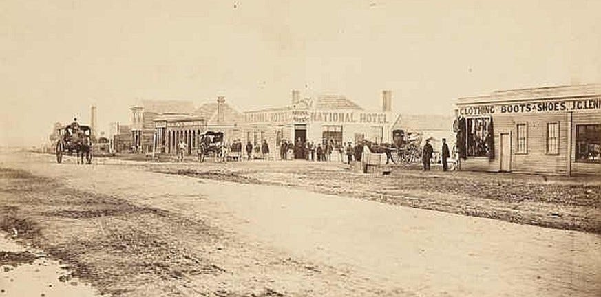
Albert St., Sebastopol, Victoria, 1866. Photographer unknown. State Library of Victoria. Sebastopol
The Sligos’ home from 1870 to 1872 was Clunes, around 36 kilometres north of Ballarat, and the venue of Victoria’s first registered gold find in July 1851. At that stage, Clunes was a significant site of goldmining with many different work possibilities for Archie. The town is probably best remembered today for a major industrial dispute in 1873 when mine owners attempted to reduce miners’ wages and conditions and brought in Chinese labourers as strike-breakers. However, the miners successfully resisted and formed the Clunes Miners’ Association, an early antecedent of the Australian Construction, Forestry, Mining and Energy Union.[2]
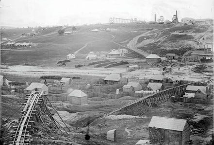
Port Phillip & Colonial Gold Mining Co., Clunes. Photographer Richard Daintree, 1861. Collection State Library Victoria. Miners’ houses are in the foreground, some with washing on the line. The scale of the industrial enterprise suggests the transition referred to in earlier posts from poor man’s to rich man’s mining. Clunes
Clunes was also the birthplace of Archie and Jessie’s short-lived second daughter, Jane Elizabeth, the couple’s second loss of an infant in Australia. Max Hodgson reproduces a “Register of Certified Cases of Successful Vaccination” from Clunes. This gives the date of Jane Elizabeth’s “registration” of vaccination (against what is not stated) as 15 May 1871. However, her death certificate, dated 30 May, states she had an illness of two weeks. Jane may have reacted fatally to the vaccine, or possibly the vaccination came too late to prevent the disease. The eldest boy, Alexander, was 12 and Willie, 11, when the family’s baby died of “bronchitis and abscess of throat” at eight months of age.
On 14 May 1872, almost a year after Jane’s death, another daughter, Jessie, named after her mother, was born in Dunolly; Archie was still listed as a miner. Probably shortly after that, the family bought a farm somewhere near Bealiba, the precise location undetermined at this point. The little township of Bealiba had enjoyed a minor gold rush from 1856 onwards, but before long, this petered out. Thereafter, local prosperity was derived more from timber milling and farming.[3]
Although now farming, Archie and his growing sons continued to be involved in mining; this was the family passion and had been Archie’s life for 20 years. Bealiba’s centrality in this goldmining district also kept the family in touch with the day’s mining news.
Norman Sligo’s obituary states that although born in Ballarat, he spent his early childhood on “his father’s farm at Goldsborough, on the line of the famous Bealioa [i.e., Bealiba] and Moliagul alluvial gold leads.” In Willie’s obituary, it says, “he received his early education at Clunes and Goldsborough under a veteran pioneer school master, Mr John Kirkcaldie.” The size of the family increased again on 20 March 1874, with the arrival of twins Elizabeth Jane and George.
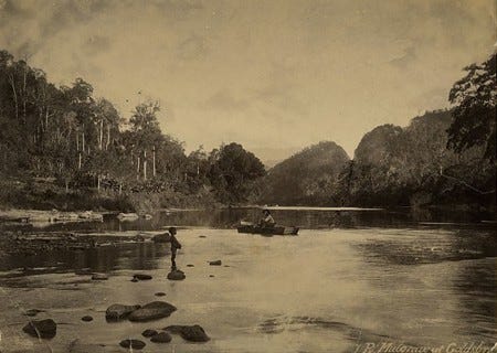
River Mulgrave at Goldsborough, 1890. Photographer Sidney Ricardson. River Mulgrave
In December 1875, John Albert was born at Goldsborough. Despite some advances in medicine and sanitation, child mortality was still high, and the family encountered a third loss with their new infant dying on 11 March 1876. The cause of death was given as diarrhoea, and the illness lasted just two days.
Notwithstanding Archie’s farming work, on John’s death certificate, the father’s occupation was still given as miner, indicating how people of the time would turn their hands to diverse activities as opportunities presented themselves.
Archie’s father, Archibald Senior, had died in Scotland a little more than a month before, but news of his death would take another couple of months to reach this family.
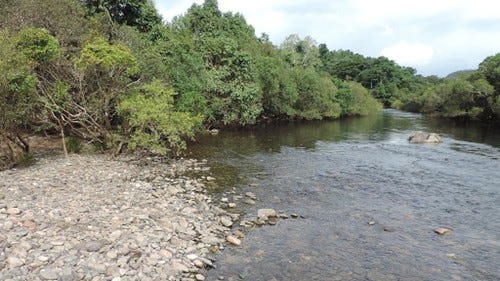
Mulgrave River, Goldsborough Valley Road Over Bridge to the Wooroonooran National Park, Goldsborough. Photographer Kerry Raymond, 2018. Mulgrave River
Back to Dunedin: Three Figures and Gumtrees
The photo below is the only one that my grandfather Willie Sligo pasted in a scrapbook of newspaper clippings, such as his published letters to newspapers and cartoons that had taken his fancy. However, he provided no record of who the people were, their location, or when the photo was taken.
As mentioned, Archie and Jessie owned a farm in the old mining district of Mt. Bealiba/ Goldsborough. The eucalyptus trees and the landscape’s open nature suggest that the photo was taken in Australia, not New Zealand.

Since the image was evidently significant to Willie, I’m speculating that he took the photo and that it shows his parents, Archie and Jessie and perhaps his younger sister, Grace Anna. Despite owning their farm in Bealiba, after ten years in Australia and by the late 1870s, it seems they were thinking about heading back to Otago.
Family historian Max Hodgson thinks Willie may have been the first of this family to return to Otago in 1877, aged 18. If that is the date of the image, then Willie’s father, Archie, would have been aged about 44 and his mother, Jessie, about 43. Grace Anna was born in 1864 at Saddle Hill during the family’s first residency in Otago (from 1861/2 to 1864/5) and thus would be around 14 in the photo.
If Willie was the first to go, his trip could have been in the nature of a prospecting expedition on behalf of the family, for his obituary states his return to Dunedin as an adult was at the age of 21, which would be 1880. Eighteen-eighty is also the date given in his younger brother Norman’s obituary for his arrival in Dunedin, so if the newspaper reports are accurate, this may be when the family made its move.
The photo was posed, but the figures are dwarfed by the land, the trees, shrubs, and the stream that occupies the foreground. A dammed stream would have been crucial in providing water for the family and their animals in Victoria’s dry terrain.
It is not hard to see the photo as a farewell and an elegy to this site, given its focus on the land as much as on the people present. In some ways, the main actor seems to be the setting, and the figures within it are adjuncts to the place. Later in life, Willie showed his skills as an accomplished landscape artist. As in his oil paintings as well, reproduced in a following post, the land is what matters. If people appear in the frame at all, they are subsidiary to the presence of nature. This could have been his farewell photograph and a keepsake both of his family and the land where he spent his adolescent years.
Another possible inducement for relocation might have been that Archie’s older brother Alex was settled in Dunedin, having owned his own business there since 1871. Hence, he may have encouraged his brother and family in Australia to return to the site of their earlier life. The town was derided as Mudedin no more: Otago’s wealth derived from gold and wool and the associated economic upturn had made Dunedin the most affluent of the country’s towns.
By 1874, Dunedin had become New Zealand’s largest city, with a population of about 30,000, almost twice the size of the capital, Wellington, at 16,000. Dunedin was now commercially pre-eminent, the leading city in the colony, and the site of a vast building boom financed by wool, gold and the fortunes made around them.[4]

From the album Panorama of Dunedin, Otago, N.Z., 1874, Dunedin, by Burton Brothers. Te Papa (O.025696) Dunedin
After selling their farm, the family returned to Otago, this time permanently, when the parents were in their mid-forties, Willie, aged 21 and Grace Anna, 15. The exact date is unknown, but before 1882, when the electoral roll reveals the family living in Clarendon St, Dunedin. It also shows that Archie had found work as a waterworks inspector at the age of 48. Undoubtedly, his life had been highly strenuous, coping as he had with the gruelling labour and diverse climatic extremes of mining in Scotland, Australia and New Zealand. In 1899, he was to die of silicosis, known then as the miner’s disease, so perhaps Archie was already feeling the effects of damaged lungs at that time.
Professions such as waterworks inspector were coming into their own at the time. The transition from poor man’s to rich man’s mining meant that large industrial ventures were underway, and the community was asking for some supervision and accountability, given rising expectations about improving miners’ safety and reducing environmental damage.
Gold Mining Via Leads
By the 1870s, it was evident that even though the easily won alluvial gold was largely played out, much gold remained under the ground. How to find it? Archie and Jessie’s children grew up during this evolutionary phase of gold mining and realised that to succeed in this industry, they needed education, an understanding of mining hazards and safety, and engineering expertise. They had to learn about gold mining using leads, the term meaning the way in which miners would dig shafts to reveal ancient, buried remnants of gold deposits; leads were what they called the primeval river courses they sought to follow.
As lead mining became more prevalent, its dangers increased in proportion to the depths to which the gold was pursued, especially from cave-ins and flooding. The aim was to dig tunnels beneath or alongside old, buried riverbeds to extract the gold-bearing gravels via connecting tunnels. This was seldom straightforward or safe, so ever-increasing geological knowledge and engineering ability levels were required.
Willie and his brothers formed a new cohort of hard-rock miners, far more attuned than their parents ever had to be to the crucial nature of geological knowledge and the need for advanced engineering practices for reef mining and dredging. Then, since poor man’s mining was no longer viable, Willie and his brothers needed the ability to persuade investors to see the merits of what they had in mind and to part with sufficient capital to fund their endeavours.
Especially for the brothers Alex, Willie, Norman, and James, though they had other occupations, especially later on in their lives, mining formed the central part of their existence. They would have seen themselves in many ways as citizens of both Australia and New Zealand, moving at will between countries into new fields as gold discoveries occurred.
During the 1870s, gold-bearing reefs were being discovered in the vicinity of Central Otago’s little settlement of Macetown. Reefs are deposits of gold still embedded in their original host rock. Few people were interested in attempting to win gold by this means, given the challenges of inaccessible landscape and harsh climate.
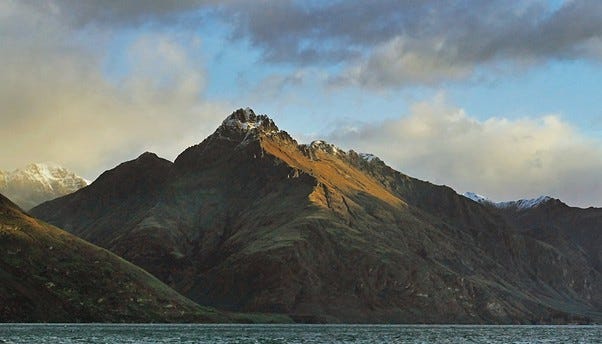
Walter Peak, Otago. Photographer Bernard Spragg, 2016. Walter Peak
Yet by the early 1880s, when Willie was still in his early 20s, developments in engineering and electrical technology, such as the first use of hydroelectric power, began to give this new generation of miners insights into how to extract wealth from these reefs of quartz-bearing gold in the Otago hills.
The emerging society started to realise the value of that new commodity, electricity, now coming available from hydroelectric installations. These would produce the power increasingly sought by a growing manufacturing industry, and private homes starting to clamour for electric light and heating.
Quartz reef mining followed the gold deposited in the quartz. The reefs were generally mined in strips, leaving large sections in the ground where the reef had been. Heavy crushing equipment in the form of large stamping batteries driven by steam engines or by hydro power was now needed, the quartz rendered to fine sand, then washed out along riffled trays to extract the gold. When in operation, the cacophonous din of these huge batteries could be heard from miles away as their giant hammers pounded the hard rock into dust.
These stone-shod glaciers
Willie was fascinated by geology and became a largely self-taught student of the underground forces associated with how gold was created and distributed. As pointed out in his obituary, “He had a practical knowledge of mining, particularly of reefing, and he also devoted much time to the study of geology and scientific mining data”. In one of his newspaper articles, he recalls a conversation among miners as they puzzled about how the gold found its way in quantity to some points in the landscape but not to others. Then, alluding to himself as more advanced, he recounted how:
A more advanced student of nature’s forces would modestly explain the alteration in the configuration of the country caused by erosion over a long period of time, and he would draw pictures of a long way back when glaciers ploughed their way south from away beyond Soho, Mount Just, and Mount Hyde, carrying with them thousands of tons of rich quartz torn out of the reefs. In course of time the stone became disintegrated and the gold liberated. Valleys were formed by these stone-shod glaciers. Following on these ice movements, rivers were formed on higher planes than at present, and as time went on the glacier deposits of earlier days were swept out of the gorges by heavy flood waters caused by the melting snow and ice, thus enriching the lower levels by concentrating the gold in narrow areas. The specific gravity of gold always impelled it downwards. If the bed rock was soft the gold remained; if hard, the gold was carried forward by moving gravels or drift detritus until a holding place was reached. In places these old high-level riverbeds were protected by bars of reef which prevented the gravels and gold from being swept down to the lower levels, and after the easily won gold on the rivers and low terraces was secured the high level gold or back leaders were discovered.[5]
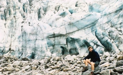
The Stone-shod Fox Glacier/ Te Moeka o Tūawe and Author, Westland Tai Poutini National Park, 1990s, photographer Michelle Branney.
The miners were starting to unpick the mysteries of how geological and climatic forces, operating over millions of years, had created an array of circumstances under which gold might accumulate in alluvial, reef or deep lead formations. These conditions constructed geological conundrums that this new generation of scientifically minded miners had to solve to win the more deeply hidden treasure. Each type of deposit possessed its own challenges and demanded a particular array of methods if its gold was to be claimed.
Macetown
Immediately upon his return to New Zealand, Willie, his brothers, and other adventurers began attempting, despite adverse climatic and geographical challenges, to open up the Macetown gold reefs, including the Maryborough, Keep It Dark, and Garibaldi. He called his Macetown reef the Golden Treasure but also invested in the Ladye Fayre and others.
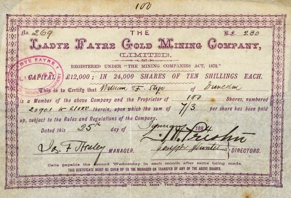
Share certificate for a Macetown mine, the Ladye Fayre.
Four substantial mountains overshadowed Macetown. These were Advance Peak (separating the Macetown valley from the Shotover River) and Mt Soho, around 5,700 ft, to the north and east of the town, then Big Hill and Government Hill to the south and west. Because of the altitude and severe climate, mining in winter was all but impossible. The Arrow River was frozen almost entirely for months, and horses had to be shod with specially sharpened shoes to permit them some grip on the ice. Even so, the precipitous icy terrain was such that occasionally, horses and people fell to their death.
Shotover River, shown with State Highway 6 Bridge. Photographer Bernard Spragg, 2013. Shotover River
.jpg)
Initially, no wagon supplies were possible to Macetown’s isolated site, which could be reached only by people walking or riding, where possible, following a zig-zag track over a steep saddle rising to over 3000 ft.[6] All supplies, machinery, etc., had to be carried in by packers, men with packhorses, or using sledges where possible. By 1884, access to Macetown had become a little easier, at least in fine weather, with the completion of the dray road up the Arrow gorge.[7]

Carrier’s Waggon, Otago, 1876-1880, Otago, photographer William Hart, Hart, Campbell & Co. Te Papa (C.015281) Carrier's Waggon
The vagaries of the weather were such that regular food supplies could not be guaranteed. To reduce the risk of uncertain provisions from Arrowtown, the nearest other settlement, Willie and business partners James Adams and Thomas Colson established a butcher’s shop and store at Macetown.[8] Storekeepers were critical in prolonging the life of small communities like this one. It was standard for them to offer the miners credit or grubstake until they had won some gold. In nearly all cases, the storekeepers were engaged in mining ventures of their own. This business proved profitable until shrinking returns from the reefs sent miners seeking their fortune elsewhere.[9]
Among the Central Otago gold settlements, Macetown was unique in its isolation and unusually harsh climate. Rather than face the perils of being cut off entirely from any other township and possibly face starvation, many Macetown residents would choose to relocate to Arrowtown or elsewhere for the duration of the winter.

Macetown, Central Otago, 1876, photographers William Hart, Hart, Campbell & Co. Te Papa (C.014902) Macetown
However, regardless of technological advances that now permitted reef mining, climate extremes in and around Central Otago remained enormously challenging. In his recollections of the Arrow River and Macetown goldmining published in the Otago Witness in 1922, Willie portrayed how “The cold in the winter was so intense that the horses [from crossing the rivers] would be impeded by dozens of icicles hanging from their tails, manes, and stomachs”.
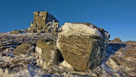
Ice Crystals near Castle Rock, Rock and Pillar Range, Otago. Photographer Thomas Sobek, 2014. Ice Crystals
And not just horses. Eileen Beaton reported how Macetown’s teenaged Adie Partridge would saddle her horse every Thursday after school and wend her way 15 kilometres down the trail to Arrowtown to take piano lessons from the Sisters of St Joseph in their convent school. Naturally, like any modest young woman of the time, she rode side-saddle, wearing a long, heavy riding skirt. The trip to and from Arrowtown required multiple fordings of the Arrow River, soaking horse and rider. In winter, the skirt would be frozen stiff by the time Adie made it home, and when taken off, “the skirt would stand up straight and would have to be thawed out!”.[10]
View From Isthmus Peak Trail to Lake Hawea. Photographer Michal Klajban, 2019. Lake Hawea
The cold extremes in Central Otago daunted all but the toughest, as recounted by Willie in another of his mining reminiscences, this time on the Shotover River. In The Otago Daily Times in 1929, two years before his death, Willie recalled how, during the winter, neither people nor horses could traverse the upper stretches of the Shotover. Despite horseshoes designed to try to cope with an icy surface, horses would shy, unable to adapt to the terrain’s extremes. The profoundly ice-bound nature of the trails defeated attempts to travel in winter and made such trips impossibly hazardous:
Where small streams passed over the high cliffs in the summer months, huge icicles formed there in the winter, reaching from some hundreds of feet above down to the partly ice-covered river. Then in the spring, when the snow began to melt and the ice thawed, the river became a raging torrent. On one occasion a number of miners lost their lives through pitching their tents too close to the river, which rose suddenly during the night with dreadful results.[11]
Yet, the opinion of the day was that becoming accustomed to cold was energising for the spirit and generally healthful, such as in Eileen Beaton’s account of Rebecca, the first female child to be born in Macetown. Rebecca’s birth was in a tent in mid-winter 1865, “and such an invigorating start kept her in excellent health all her life”.[12]
In fact, people probably had little choice other than to adopt such Spartan attitudes to tolerating cold. At that time, other than some scrubby remnants of manuka, virtually no firewood was to be had locally. Also, the cost of carting bags of coal into such remote sites was sufficiently high to encourage their frugal use.

Macetown, 1860-1870s, Otago, by Burton Brothers. Te Papa (O.026293) Macetown
In a similar vein, Willie told of Oliver Palmer, one of a dozen Macetown miners, enthusiastic imbibers to a man, known to all as the Twelve Apostles. Palmer, on the coldest nights, “would sometimes don an old coat, but his chest was always exposed, and his bright smile haunts me still”.[13]
The Twelve Apostles, in Willie’s words, “in the palmy days of Macetown were renowned Bacchanalians. They were mostly quite harmless because they were generally quite helpless although when sober they were good-natured, happy-go-lucky fellows”.
Eileen Beaton remarks rather tartly that “The Twelve Apostles were so named by their numbers only”, but “In spite of their excessive drinking, the Apostles were very healthy. All reached their allotted ‘three score and ten’. Some died in the Arrowtown Hospital and some at Macetown”.[14]
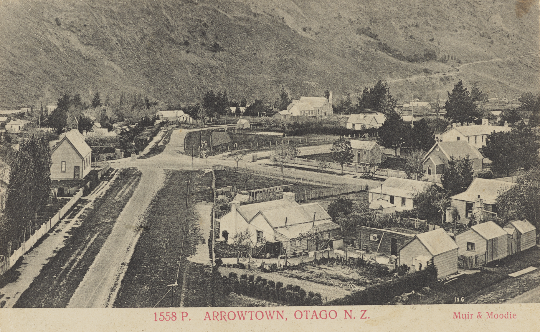
Arrowtown, Otago, 1905, photographers Muir & Moodie. Te Papa (PS.001537) Arrowtown
Coming Up:
His Wife Burst into Tears, Saying She Had Already Mortgaged Their Home so She Could Pay for Her Own Dredge Speculations.
An Irresistible Feeling of Solitude Overcame Me. There Was No Sound: Just a Depressing Silence.
Norman Conceded in His Mind that the Boomerang Would Crash Home Before He Could Snatch Out His Revolver.
The Sin of Cheapness: There Are Very Great Evils in Connection with the Dressmaking and Millinery Establishments.
The Poll Tax: One of the Most Mean, Most Paltry, and Most Scurvy Little Measures Ever Introduced.
Holy Wells: We are Order and Disorder.
God is Good and the Devil’s Not Bad Either, Thank God.
Notes
[1] Alluvial gold leads at Sebastopol
[2] Clunes, Victoria, n.d.
[3] Bealiba, n.d.
[4] King, 2003, p. 209.
[5] Sligo, 1922a.
[6] Salmon, 1963, p. 119.
[7] Macetown and the Arrow Gorge, p. 7.
[8] Obituary, Otago Daily Times, June 29, 1931.
[9] Macetown and the Arrow Gorge, p. 7.
[10] Beaton, p. 51.
[11] Sligo, 1929.
[12] Beaton, 1971, p. 37.
[13] Sligo, 1922.
[14] Beaton, 1971, p. 48.
References
Alluvial gold leads at Sebastopol (n.d.). Downloaded on October 8, 2023, from http://www.ballaratgenealogy.org.au/sebastopol/leads.htm
Bealiba. (n.d.). Downloaded on October 18, 2023, from https://www.bendigoregion.com.au/visit-maryborough-surrounds-victoria/bealiba
Beaton, E. (1971). Macetown: The story of a fascinating gold-mining town. John McIndoe.
Clunes, Victoria. (2023). Downloaded on October 18, 2023, from http://en.wikipedia.org/wiki/Clunes,_Victoria
King, M. (2003). The Penguin history of New Zealand. Penguin Books.
Macetown and the Arrow Gorge: Otago Goldfields Park. (n.d.). The Department of Lands and Survey.
Obituary, Mr W.F. Sligo. Otago Daily Times, (1931, June 29) p. 7.
Salmon, J.H.M. (1963). A history of goldmining in New Zealand. Government Printer.
Sligo, W.F. (1922, 11 July). The old goldfields days. Macetown in the eighties: The old reefs and the old reefers. Some personal reminiscences – No. I. Otago Witness, p. 6.
Sligo, W.F. (1929, May 28). Old days on the Shotover: A mining retrospect and a new venture. Otago Daily Times, p. 14; and reprinted in the New Zealand Tablet, (1929, June 5) p. 15.